The route of the Lariani Mountains
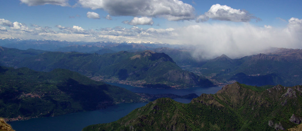
It is a beautiful hiking route that from Cernobbio connects localities scattered along the mountains of the western shore of Lake Como, reaching Sorico, after a journey of 125 km.
Many of these locations, included in a range varying from 600 to 1200 meters above sea level, were once mountain pastures (called mûnt), hence the name "Via dei Monti Lariani", intended precisely as a connecting road between these ancient settlements. It is divided into 4 stages:
Path 1: Cernobbio – San Fedele – Length 28 km – time: approximately 9 hours
Path 2: San Fedele – Grandola ed Uniti – Length 26 km – time: approximately 9 hours
Path 3: Grandola ed Uniti – Garzeno – Length 30 km – time: approximately 9 hours
Path 4: Garzeno – Sorico – Length 46 km – time: approximately 3.30 hours
Here we describe the first and second paths, which lie on the territory of our map:
PATH 1 OF THE VIA DEI MONTI LARIANI
From Monte Bisbino (1325 m) to the mountains of the Intelvi Valley
The route starts from Cernobbio, Fraz. Rovenna, climbs to the summit of Monte Bisbino, then takes the path behind the Sanctuary and continues through the pine forest towards the Scarone Mountains, the Madrona Mountains, the San Carlo Chapel, up to Colma del Bugone (1111 m) – Refuge in a former Finance Barracks.
Going around the Poncion della Costa, you reach Colma dei Murelli (1200 m) – Refuge – from where you can deviate towards the Cima del Monte S. Bernardo (1349 m), – ancient chapel of the same name – wide view of Lake Como. You then reach Colma di Binate (1300 m), then the Casino dei Signori (a location known for an episode of the 1848 insurrection). You arrive at Colma di Schignano in Crocette, go around the Sasso di Gordona and arrive at the CAI Prabello refuge.
The mule track descends to the Piano delle Alpi, continues through the ancient farmhouses of Ermogna and Carolza and reaches Capanna Bruno (CAI refuge). With two possibilities: you descend directly across the carriage road towards Alpe Grande or, continuing through the mountains, you reach Bocca di Orimento surrounding Pizzo della Croce, from where the path to Monte Generoso starts.
From Orimento you go down to the Rifugio del Monte Cristè (CAI), then skirting the Alpe Grande plain (bubbles) and passing through the Meriggio locality you reach S.Fedele (Postiglione locality – Courier depot).
PATH 2 OF THE VIA DEI MONTI LARIANI
Tremezzina mountains
From S. Fedele you go up to the Belvedere locality (view of the Valley), to the Bocchetta della Zerla (remains of Roccolo), to the Cascina Bassetta (ruins) and you arrive at the Bocchetta di Colonno.
You descend to the Boffalora Pass, a possible detour to Ossuccio or Ponna, you go up to the Pra Grassa area from where two itineraries, through the Bocchetta di Nava, reach Croce (fraction of Menaggio): low = Piazza, Monti Brente; high = Alpe Ossuccio, Alpe di Lenno, Rifugio Venini, Alpe di Tremezzo, Monte Crocione, Monti Brente. The itinerary partly retraces an ancient shepherd's road and allows you to visit the remains of fortifications and roads of the Cadorna Line.
